
Climate change, droughts, uncontrolled water reservoir, growing populations are the main causes for modern day flood and famine. The best way to eliminate excessive floods and its devastating effect is effective early prediction and planning. Developing more green mass and keeping the trees intact on the soil is a key issue to prevent flood. About 70 million people globally exposed to flooding every year, and more than 800 million living in flood prone areas. Flood and famine causes widespread and acute malnutrition and death by starvation and diseases. Lack of effective flood and famine prediction system and lack of awareness of flood risk and the ineffectiveness of efforts towards tackling flooding in many places are factors of major concern across the world.
In our Sri Amit Ray Compassionate AI Lab, we experimented with different Artificial Intelligence-based machine learning algorithms for active and early flood and famine prediction, planning, coordination, and awareness development. With the rapid growth of the Internet of Things (IoT), satellite and radar imaging technologies, sensor technologies, and deep learning algorithms of AI, it is possible to predict flood situations in advance, which integrates remote sensing (RS), Geographical Information Systems (GIS), and Global Positioning Systems (GPS).
With the help of this prediction we can prevent human loss and a lot of secondary disasters such as mudflows, landslides, desertification, and water shortages and immense property losses to people and overall economic losses.
“Unless you truly feel the pain and sufferings of the people and the living beings in flood, famine, poverty, disease, exploitation, and hunger – you cannot grow spiritually, scientifically, politically, and socially.” — Amit Ray
Top Six Causes of Flood:
Flooding is caused by several factors and is invariably preceded by heavy rainfall. The other causes of flooding are moderate to severe winds over water, unusual high tides, tsunamis due to undersea earthquakes, breaks or failures of dams, levees, retention ponds or lakes, and other infrastructure that retains water. The uneven distribution of water resources is one of the main causes floods.
Generally, causes of flood could be as a result of natural cause or human cause. The top six causes of floods are: heavy or torrential rains/rainstorm, ocean storms and tidal waves, coastal flooding, river flooding, flash floods, and dam burst or dam spills.
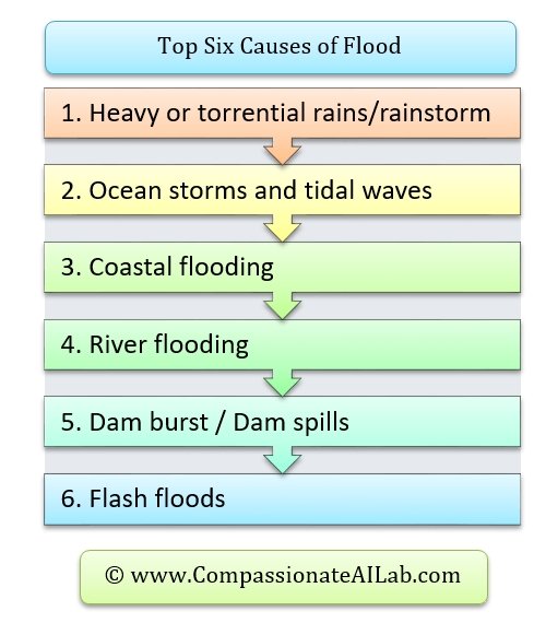
Top Six Causes of Flood
Top Modules of the AI Based Flood Prediction System
We have used several hybrid modelling approaches. The seven top modules of our AI based flood warning system are: surface water cycle module, surface hydrology module, hybrid satellite and radar based rainfall prediction module, daily reservoir inflow-outflow forecasting module, river network structure and connectivity module, global atmospheric circulation module, and snowmelt flood forecasting module.
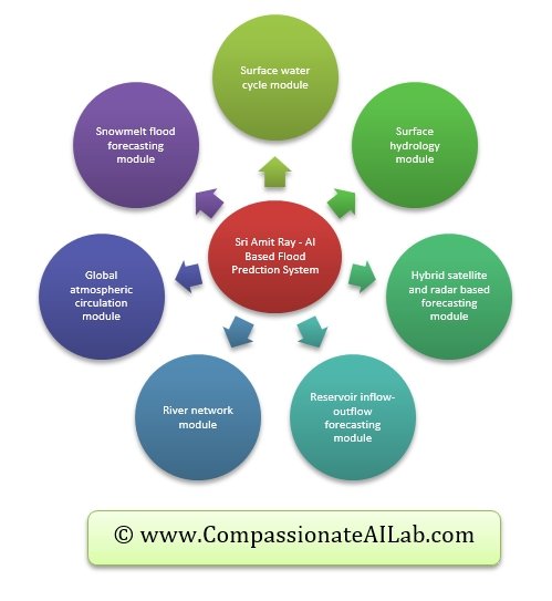
Sri Amit Ray model for AI Based Early Flood Forecasting
Key AI Technologies for Flood Prediction
We have experimented with several classical models and deep learning hybrid modelling approaches. Since the behavior of flood data time series is very much non-linear and seasonal Recurrent Neural Networks (RNN) based deep learning models are best suited. We have used RNN (Recurrent Neural Networks), LSTM (Short Term Memory Networks) & GRU (Gated Recurrent Unit Network) to predict the time series data. LSTM ’s and GRU’s have the the solution with short-term memory. They have internal mechanisms called gates that can regulate the flow of information. GRU’s got rid of the cell state and used the hidden state to transfer information.

RNN LSTM and GRU Deep Learning
We have used tanh and Rectified linear unit (ReLU) activation functions. The tanh activation is used to help regulate the values flowing through the network. The tanh function squishes values to always be between -1 and 1.
AI for Image Classification
A convolutional neural networks (CNN) deep learning algorithms have been successfully used to create a system able to handle the classification of satellite image data without any human’s interactions. We have used AlexNet, VGG19, GoogLeNet and Resnet50 pre-training models for feature extractions. The model is used for identifying critical areas of flood and water levels. The general structure of CNN is a series of layers including a convolutional layer, a pooling layer, and full connection layers.
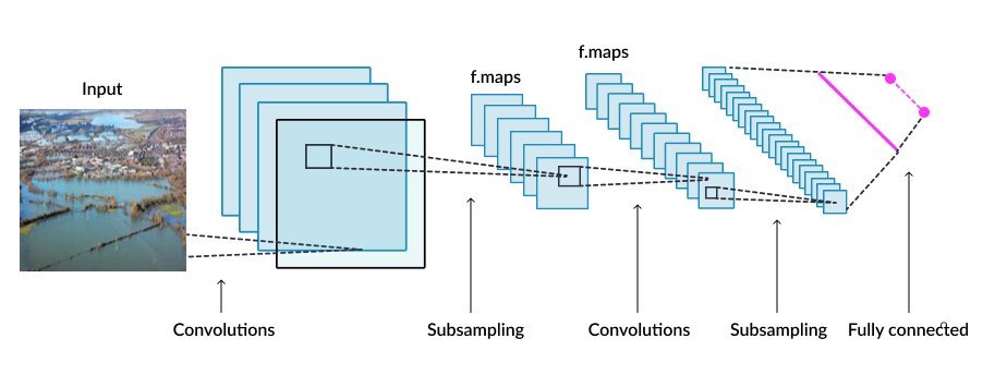
CNN Image Classification
Ocean Circulation Module
Deep learning modules for the ocean circulation pattern is the most challenging. Ocean circulation is an important player in the global climate, regulating weather patterns. Ocean currents formed by global wind patterns and forces created by Earth’s rotation. The five major circulation patterns formed by the currents are the world’s five major ocean gyres: North Atlantic, South Atlantic, Indian, North Pacific, and South Pacific.
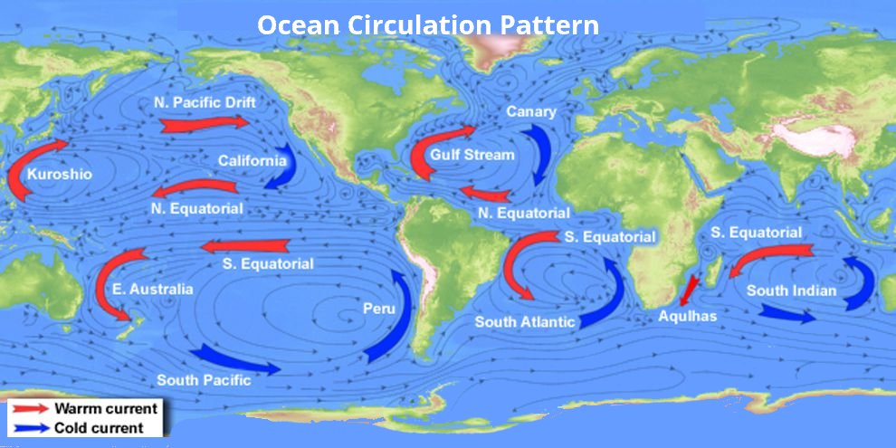
Ocean Current Deep Learning Module
AI Based Famine Prediction
Famines are generally caused by natural disasters like drought, storm, flood and earthquake or by the human-made disasters like war, refugee migration, state failures, internal political crises, external political crises. Famine prediction for using AI tools are relatively easy. But it is very difficult to predict the human-made disasters. Traditionally, famine indicators like agricultural production, agricultural shocks, household income and labor input are used in establishing the link between different variables used to detect famine. However, in our model we focused on more robust methods to include both natural disaster indicators and human created disaster indicators.
Conclusion
With AI technology and real-time data, it is possible to prevent many disasters, famine and human life. Prediction and monitoring of flood and famine situations across the world is relatively easy. But the biggest challenge is the effective mobilization of disaster relief. Proper shelter, medicine, safe food and water supplies are a significant concern.
Recently, Cyclone Idai has created destruction in many parts of Mozambique, Malawi, and Zimbabwe. It could become one of the worst weather-related disasters to hit the Southern Hemisphere in this decade. Hundreds have died and as many as 600,000 people have been displaced, according to the World Food Programme.
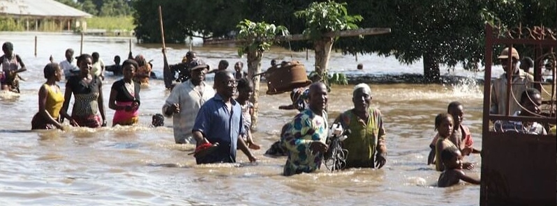
Recently, flooding has affected different parts of the world specially India and Nigeria. In Nigeria over 6,800 people living in displacement camps in Maiduguri had been impacted by floods. In Dikwa, 500 people had been rendered homeless due to flooding.An estimated 8,875 households (HH) have been affected by torrential rains and flash floods across Borno and Yobe states. With the development of AI-based flood forecasting tools, this type of loss can be minimized.
In 2017, about 20 million people across north-eastern Nigeria, Yemen, Somalia, South Sudan, and encountered famine or famine-like conditions. This famine was the result of a complex intersection of conflict, poverty, flood, climate change, corruption and food prices. United Nations along with international organizations launched Famine Action Mechanism (FAM) programs. But the ground level requirements are much more than that. It needs more initiatives and more effort.
Based on historical data on flooding, the modules are tested, but a lot of work remains to be done — the lack of flood data and other ancillary data, which is a significant setback towards tackling flooding.